2.3.2.1 Palaeoclimate proxy indicators
A proxy climate indicator is a local record
that is interpreted using physical or biophysical principles to represent some
combination of climate-related variations back in time. Palaeoclimate proxy
indicators have the potential to provide evidence for large-scale climatic changes
prior to the existence of widespread instrumental or historical documentary
records. Typically, the interpretation of a proxy climate record is complicated
by the presence of noise in which climate information is immersed,
and a variety of possible distortions of the underlying climate information
(e.g., Bradley, 1999; Ren, 1999a,b). Careful calibration and cross-validation
procedures are necessary to establish a reliable relationship between a proxy
indicator and the climatic variable or variables it is assumed to represent,
providing a transfer function through which past climatic conditions
can be estimated. High-resolution proxy climate indicators, including tree rings,
corals, ice cores, and laminated lake/ocean sediments, can be used to provide
detailed information on annual or near-annual climate variations back in time.
Certain coarser resolution proxy information (from e.g., boreholes, glacial
moraines, and non-laminated ocean sediment records) can usefully supplement
this high-resolution information. Important recent advances in the development
and interpretation of proxy climate indicators are described below.
Tree rings
Tree-ring records of past climate are precisely dated, annually resolved, and
can be well calibrated and verified (Fritts, 1976). They typically extend from
the present to several centuries or more into the past, and so are useful for
documenting climate change in terrestrial regions of the globe. Many recent
studies have sought to reconstruct warm-season and annual temperatures several
centuries or more ago from either the width or the density of annual growth
rings (Briffa et al., 1995; DArrigo et al., 1996; Jacoby et al., 1996;
DArrigo et al., 1998; Wiles et al., 1998; Hughes et al., 1999; Cook et
al., 2000). Recently, there has been a concerted effort to develop spatial reconstructions
of past temperature variations (e.g., Briffa et al., 1996) and estimates of
hemispheric and global temperature change (e.g., Briffa et al., 1998b; Briffa,
2000). Tree-ring networks are also now being used to reconstruct important indices
of climate variability over several centuries such as the Southern Oscillation
Index (Stahle et al., 1998), the North Atlantic Oscillation (Cook et al., 1998;
Cullen et al., 2001) and the Antarctic Oscillation Index (Villalba et al., 1997)
(see also Section 2.6), as well as patterns of pre-instrumental
precipitation and drought (Section 2.5.2.2).
Several important caveats must be borne in mind when using tree-ring data for
palaeoclimate reconstructions. Not least is the intrinsic sampling bias. Tree-ring
information is available only in terrestrial regions, so is not available over
substantial regions of the globe, and the climate signals contained in tree-ring
density or width data reflect a complex biological response to climate forcing.
Non-climatic growth trends must be removed from the tree-ring chronology, making
it difficult to resolve time-scales longer than the lengths of the constituent
chronologies (Briffa, 2000). Furthermore, the biological response to climate
forcing may change over time. There is evidence, for example, that high latitude
tree-ring density variations have changed in their response to temperature in
recent decades, associated with possible non-climatic factors (Briffa et al.,
1998a). By contrast, Vaganov et al. (1999) have presented evidence that such
changes may actually be climatic and result from the effects of increasing winter
precipitation on the starting date of the growing season (see Section
2.7.2.2). Carbon dioxide fertilization may also have an influence, particularly
on high-elevation drought-sensitive tree species, although attempts have been
made to correct for this effect where appropriate (Mann et al., 1999). Thus
climate reconstructions based entirely on tree-ring data are susceptible to
several sources of contamination or non-stationarity of response. For these
reasons, investigators have increasingly found tree-ring data most useful when
supplemented by other types of proxy information in multi-proxy
estimates of past temperature change (Overpeck et al., 1997; Jones et al., 1998;
Mann et al., 1998; 1999; 2000a; 2000b; Crowley and Lowery, 2000).
Corals
Palaeoclimate reconstructions from corals provide insights into the past variability
of the tropical and sub-tropical oceans and atmosphere, prior to the instrumental
period, at annual or seasonal resolutions, making them a key addition to terrestrial
information. Because of their potential to sample climate variations in ENSO-sensitive
regions, a modest network of high-quality coral site records can resolve key
large-scale patterns of climate variability (Evans et al., 1998). The corals
used for palaeoclimate reconstruction grow throughout the tropics in relatively
shallow waters, often living for several centuries. Accurate annual age estimates
are possible for most sites using a combination of annual variations in skeletal
density and geochemical parameters. Palaeoclimate reconstructions from corals
generally rely on geochemical characteristics of the coral skeleton such as
temporal variations in trace elements or stable isotopes or, less frequently,
on density or variations in fluorescence. Dunbar and Cole (1999) review the
use of coral records for palaeoclimatic reconstruction.
Ice cores
Ice cores from polar regions of northern Greenland, Canada and the islands of
the North Atlantic and Arctic Oceans, Antarctica, and alpine, tropical and sub-tropical
locations (e.g., Thompson, 1996) can provide several climate-related indicators.
These indicators include stable isotopes (e.g., 18O), the fraction of melting
ice, the rate of accumulation of precipitation, concentrations of various salts
and acids, the implied atmospheric loading of dust pollen, and trace gases such
as CH4 and CO2.
Recently, there has been increased activity in creating high-resolution Antarctic
ice core series e.g., for the past millennium (Peel et al., 1996; Mayewski and
Goodwin, 1997; Morgan and van Ommen, 1997). In certain regions, isotope information
from ice cores shows the late 20th century temperatures as the warmest few decades
in the last 1,000 years (Thompson et al., 2000a). Key strengths of ice core
information are their high resolution (annual or even seasonal where accumulations
rates are particularly high - see van Ommen and Morgan, 1996, 1997), availability
in polar and high-elevation regions where other types of proxy climate information
like tree-ring data are not available, and their provision of multiple climate-
and atmosphere-related variables from the same reasonably well dated physical
location (e.g., the GISP2 core; White et al., 1998a). A weakness of ice core
data is regional sampling bias (high elevation or high latitude) and melt water
and precipitation accumulation data are not easy to date accurately.
The best dated series are based on sub-annual sampling of cores and the counting
of seasonal ice layers. Such series may have absolute dating errors as small
as a few years in a millennium (Fisher et al., 1996). Dating is sometimes performed
using volcanic acid layers with assumed dates (e.g., Clausen et al., 1995) but
uncertainties in the volcanic dates can result in dating uncertainties throughout
the core (Fisher et al., 1998).
Lake and ocean sediments
Annually laminated (varved) lake sediments offer considerable potential as high-resolution
archives of palaeo-environmental conditions where other high-resolution proxy
indicators are not available (e.g., arid terrestrial regions), and latitudes
poleward of the treeline (Lamoureux and Bradley, 1996; Wohlfarth et al., 1998;
Hughen et al., 2000). When annual deposition of the varves can be independently
confirmed (e.g., through radiometric dating), they provide seasonal to interannual
resolution over centuries to millennia. Varved sediments can be formed from
biological processes or from the deposition of inorganic sediments, both of
which are often influenced by climate variations. Three primary climate variables
may influence lake varves: (a) summer temperature, serving as an index of the
energy available to melt the seasonal snowpack, or snow and ice on glaciers;
(b) winter snowfall, which governs the volume of discharge capable of mobilising
sediments when melting; and (c) rainfall. Laminated lake sediments dominated
by (a) can be used for inferences about past high latitude summer temperature
changes (e.g., Overpeck et al., 1997), while sediments dominated by the latter
two influences can be used to estimate past drought and precipitation patterns
(Section 2.5.2.2).
Ocean sediments may also be useful for high-resolution climate reconstructions.
In rare examples, annually laminated sediments can be found (e.g., Hughen et
al., 1996; Black et al., 1999) and it is possible to incorporate isotope and
other information in climate reconstructions, much as varved lake sediments
are used. Otherwise, sedimentation rates may sometimes still be sufficiently
high that century-scale variability is resolvable (e.g., the Bermuda rise ocean
sediment oxygen isotope record of Keigwin, 1996). Dating in such cases, however,
must rely on radiometric methods with relatively poor age control.
Borehole measurements
Borehole measurements attempt to relate profiles of temperature with depth to
the history of temperature change at the ground surface. The present global
database of more than 600 borehole temperature-depth profiles has the densest
geographic coverage in North America and Europe, but sparser data are available
in other regions (e.g., Australia, Asia, Africa and South America). The depths
of the temperature profiles range from about 200 to greater than 1,000 m, allowing
palaeo-temperature reconstructions back several hundred to a thousand years.
Although large-scale temperature reconstructions have been made to more than
a millennium ago (Huang et al., 1997), they show substantial sensitivity to
assumptions that are needed to convert the temperature profiles to ground surface
temperature changes. Borehole data are probably most useful for climate reconstructions
over the last five centuries (Pollack et al., 1998).
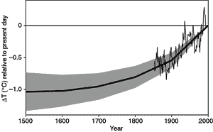
Figure 2.19: Reconstructed global ground temperature estimate from
borehole data over the past five centuries, relative to present day. Shaded
areas represent ± two standard errors about the mean history (Pollack
et al., 1998). Superimposed is a smoothed (five-year running average) of
the global surface air temperature instrumental record since 1860 (Jones
and Briffa, 1992). |
Figure 2.19 shows a reconstructed global ground
surface temperature history (Pollack et al., 1998; see also Huang et al., 2000)
from an average of the 358 individual sites, most located in North America and
Eurasia, but some located in Africa, South America and Australia (similar results
are obtained by Huang et al., 2000, using an updated network of 616 sites).
Superimposed is an instrumental estimate of global surface air temperature (Jones
and Briffa, 1992). The ensemble of reconstructions shows that the average ground
temperature of the Earth has increased by about 0.5°C during the 20th century,
and that this was the warmest of the past five centuries. About 80% of the sites
experienced a net warming over this period. The estimated mean cumulative ground
surface temperature change since 1500 is close to 1.0 ± 0.3°C. Uncertainties
due to spatial sampling (see Pollack et al., 1998 and Huang et al., 2000) are
also shown. It should be noted that the temporal resolution of the borehole
estimates decreases sharply back in time, making it perilous to compare the
shape of the trend shown in Figure 2.19 with better-resolved
trends determined from higher-resolution climate proxy data discussed below.
While borehole data provide a direct estimate of ground surface temperatures
under certain simplifying assumptions about the geothermal properties of the
earth near the borehole, a number of factors complicate their interpretation.
Non-temperature-related factors such as land-use changes, natural land cover
variations, long-term variations in winter snow cover and soil moisture change
the sub-surface thermal properties and weaken the interpretation of the reconstructions
as estimates of surface air temperature change. In central England, where seasonal
snow cover is not significant, and major land-use changes occurred many centuries
ago, borehole ground surface temperature trends do tend to be similar to those
in long instrumental records (Jones, 1999). In contrast, Skinner and Majorowicz
(1999) show that borehole estimates of ground surface temperature warming during
the 20th century in north-western North America are 1 to 2°C greater than
in corresponding instrumental estimates of surface air temperature. They suggest
that this discrepancy may be due to land-use changes that can enhance warming
of the ground surface relative to that of the overlying atmospheric boundary
layer (see also Lewis, 1998). Such factors need to be better understood before
borehole temperature measurements can be confidently interpreted.
Continues on next page