2.7.2.2 Precipitation
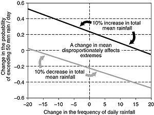
Figure 2.34: An example (from Groisman et al., 1999) of the sensitivity
of the frequency of heavy daily rainfall to a shift in the mean total
rainfall, based on station data from Guangzhou, China. This example
uses a threshold of 50 mm of precipitation per day. It shows the effects
of a 10% increase and a 10% decrease in mean total summer rainfall,
based on a gamma distribution of the rainfall with a constant shape
parameter. |
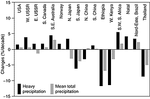
Figure 2.35: Linear trends (%/decade) of heavy precipitation (above
the 90th percentile) and total precipitation during the rainy season
over various regions of the globe. Seasons for each region usually
span at least 50 years. Note that the magnitudes of the changes in
heavy precipitation frequencies are always higher than changes in
mean precipitation totals (Easterling et al., 2000). |
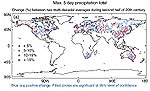 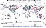
Figure 2.36: Changes in the maximum annual 5-day precipitation
total (a, b) and in the proportion of annual precipitation occurring
on days on which the 95th percentile of daily precipitation, defined
over the period 1961 to 1990, was exceeded (c, d). The analysis shown
is from Frich et al. (2001). Panels (a) and (c) show percentage changes
in these quantities between the first and last half of the period,
approximately 1946 to 1999. In both panels, the red circles indicate
negative changes and the blue circles indicate positive changes. The
size of each circle reflects the size of the change and solid circles
represent statistically significant changes. Panels (b) and (d) show
the average annual values of the quantities expressed as percentage
differences from their 1961 to 1990 average values. The trend shown
in panel (b) is statistically significant at the 5% level. |
A better understanding of the relationship between changes
in total precipitation and intense precipitation events has been achieved since
the SAR. Although many areas of the globe have not been analysed, and considerable
data remain inaccessible, enough data have been analysed to confirm some basic
properties of the changes in extreme precipitation. Groisman et al. (1999) developed
a simple statistical model of the frequency of daily precipitation based on
the gamma distribution. They applied this model to a variety of regions around
the world (40% of the global land area) during the season of greatest precipitation.
Although Wilks (1999) shows that the gamma distribution under some circumstances
can underestimate the probability of the highest rainfall amounts, Groisman
et al. (1999) applied the distribution to the upper 5 and 10 percentiles of
the distribution which are less subject to underestimation. Their analysis period
varied from region to region, but within each region it generally spanned at
least the last several decades, and for some regions much of the 20th century
(Australia, United States, Norway, and South Africa). In the model used by Groisman
et al. (1999), the mean total precipitation is also proportional to the shape
and scale parameters of the gamma distribution as well as to the probability
of precipitation on any given day. The shape parameter of the gamma distribution
tends to be relatively stable across a wide range of precipitation regimes,
in contrast to the scale parameter. Given the conservative nature of the shape
parameter, it is possible to illustrate the relationships between changes in
the mean total precipitation, the probability of precipitation (which is proportional
to the number of days with precipitation), and changes in heavy precipitation
(Figure 2.34). Given no change in the frequency
(number of days) of precipitation, a 10% change in the mean total precipitation
is amplified to a larger percentage change in heavy precipitation rates compared
to the change in the mean. Using the statistical theory of extremes, Katz (1999)
obtained results consistent with those of Groisman et al. (1999). For many regions
of the world it appears that the changes in the frequency or probability of
precipitation events are either small enough, or well enough expressed in the
high rainfall rates (Karl and Knight, 1998; Gruza et al., 1999; Haylock and
Nicholls, 2000) that an increase in the mean total precipitation is disproportionately
reflected in increased heavy precipitation rates (Figure
2.35).
Given the patterns of mean total precipitation changes (Section
2.5.2) during the 20th century, it could be anticipated that, in general,
for those areas with increased mean total precipitation, the percentage increase
in heavy precipitation rates should be significantly larger, and vice versa
for total precipitation decreases. Regional analyses of annual precipitation
in the United States (Karl and Knight, 1998; Trenberth, 1998a; Kunkel et al.,
1999); Canada (Stone et al., 1999); Switzerland (Frei and Schär, 2001);
Japan ( Iwashima and Yamamoto, 1993; Yamamoto and Sakurai, 1999); wintertime
precipitation in the UK (Osborn et al., 2000); and rainy season precipitation
in Norway, South Africa, the Nord Este of Brazil, and the former USSR (Groisman
et al., 1999; Gruza et al., 1999; Easterling et al., 2000) confirm this characteristic
of an amplified response for the heavy and extreme events.
Increases in heavy precipitation have also been documented
even when mean total precipitation decreases (for example, see Northern Japan
in Figure 2.35, or Manton et al., 2001). This can
occur when the probability of precipitation (the number of events) decreases,
or if the shape of the precipitation distribution changes, but this latter situation
is less likely (Buffoni et al., 1999; Groisman et al., 1999; Brunetti et al.,
2000a,b). For example, in Siberia for the summer season during the years 1936
to 1994 there was a statistically significant decrease in total precipitation
of 1.3%/decade, but the number of days with precipitation also decreased. This
resulted in an increase (1.9%/decade) in the frequency of heavy rainfall above
25 mm. The opposite can also occur when the number of rainfall events increases;
thus Førland et al. (1998) found no trends in 1-day annual maximum precipitation
in the Nordic countries, even when mean total precipitation increased.
There has also been a 10 to 45% increase in heavy rainfall, as defined by the
99th percentile of daily totals, over many regions of Australia from 1910 to
1995, but few individual trends were statistically significant (Hennessy et
al., 1999). In south-west Australia, however, a 15% decrease has been observed
in winter rainfall on very wet days (Hennessy et al., 1999; Haylock and Nicholls,
2000).
In Niger, a recent analysis of hourly rainfall data (Shinoda et al., 1999)
reveals that the droughts in the 1970s and 1980s were characterised primarily
by a reduced frequency of heavy rainfall events (those exceeding 30 mm/day)
rather than by a reduction in rainfall amount within heavy events. Such a result
is still consistent with the model of Groisman et al. (1999), as a decrease
in the frequency of rainfall events has been responsible for the decrease in
total rainfall. In the Sahel region of Nigeria, however, there has been a decrease
in the heaviest daily precipitation amounts, coincident with an overall decrease
in annual rainfall. This pattern is apparent throughout the Sudano-Sahel Zone,
including the Ethiopian plateau (Nicholson, 1993; Tarhule and Woo, 1998; Easterling
et al., 2000). Again, it is apparent that there has been an amplified response
of the heaviest precipitation rates relative to the percentage change in total
precipitation.
Since large portions of the mid- and high latitude land areas have had increasing
precipitation during the last half the 20th century, the question arises as
to how much of this area is affected by increases in heavy and extreme precipitation
rates. The Frich et al. (2001) analysis suggests an overall increase in the
area affected by more intense daily rainfall. Figure
2.36 shows that widely distributed parts of the mid- and high latitudes
have locally statistically significant increases in both the proportion of mean
annual total precipitation falling into the upper five percentiles and in the
annual maximum consecutive 5-day precipitation total. However, for the regions
of the globe sampled taken as a whole, only the latter statistic shows a significant
increase. Regional analyses in Russia (Gruza et al., 1999), the United States
(Karl and Knight, 1998) and elsewhere (Groisman et al., 1999; Easterling et
al., 2000) confirm this trend. Although the trends are by no means uniform,
as would be anticipated with the relatively high spatial and interannual variability
of precipitation, about 10% of the stations analysed show statistically significant
increases at the 5% level. This equates to about a 4% increase in the annual
maximum 5-day precipitation total (Figure 2.36b).
The number of stations reflecting a locally significant increase in the proportion
of total annual precipitation occurring in the upper five percentiles of daily
precipitation totals outweighs the number of stations with significantly decreasing
trends by more than 3 to 1 (Figure 2.36c). Although
not statistically significant when averaging over all stations, there is about
a 1% increase in the proportion of daily precipitation events occurring in the
upper five percentiles (Figure 2.36d). Overall,
it is likely that there has been a 2 to 4% increase in the number of heavy precipitation
events when averaged across the mid- and high latitudes.
It has been noted that an increase (or decrease) in heavy precipitation events
may not necessarily translate into annual peak (or low) river levels. For example,
in the United States, Lins and Slack (1999) could not detect an increase in
the upper quantiles of streamflow, despite the documented increase in heavy
and extreme precipitation events. It is possible that this null result is partly
due to the method of analysis, but it is also attributable to the timing of
the annual peak streamflow discharge, which in the United States is usually
in late winter or early spring. A reduced snow cover extent in the mountainous
West changes the peak river flow, as does timing of increases in heavy and extreme
precipitation reported in the United States, which is best reflected during
the warm season. Groisman et al. (2001) and Zhang et al. (2000) also show reduced
peak streamflow in areas with reduced spring snow cover extent. Nonetheless,
in much of the United States where spring snow melt does not dominate peak or
normal flow, Groisman et al. (2001) show increasing high streamflow related
to increasing heavy precipitation.
It is noteworthy that the influence of warmer temperatures and increased water
vapour in the atmosphere (Section 2.5.3) are not independent
events, and are likely to be jointly related to increases in heavy and extreme
precipitation events.