8.7 Coupled Model: Phenomena
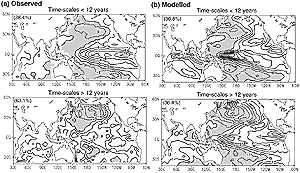
Figure 8.21: Comparison of eigenvectors for the leading EOFs of the
SSTs between the ENSO time-scale (<12 years) (upper panels) and the decadal
time scale (>12 years) (lower panels) for (a) observation, and (b) the
MRI coupled climate model, respectively (Yukimoto, 1999). Numbers in bracket
at the upper left show explained variance in each mode. |
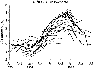
Figure 8.22: Niño-3 SST anomaly predictions and hindcast made
at various times during the 1997 to 1998 El Niño event together with
the subsequent observed SST anomaly (solid). Predictions made at ECMWF (Stockdale
et al., 1998, long dash), JMA (Ishii et al., 1998, short dash), NCEP (Barnston
et al., 1999, long short dash) and the hindcast made at BMRC (Wang et al.,
2000, dot dash) are shown. |
The atmosphere-ocean coupled system shows various modes
of variability that range widely from intra-seasonal to inter-decadal time-scales
(see Chapters 2 and 7). Since the
SAR, considerable progress has been achieved in characterising the decadal to
inter-decadal variability of the ocean-atmosphere system (Latif, 1998; Navarra,
1999). Successful evaluation of models over a wide range of phenomena increases
our confidence.
8.7.1 El Niño-Southern Oscillation (ENSO)
ENSO is a phenomenon resulting from large-scale air-sea inter-actions (see
Chapter 7, Section 7.6.5). ENSO
modelling has advanced considerably since the SAR (e.g., Yukimoto et al., 1996;
Kimoto and Shen, 1997; Knutson et al., 1997; Timmermann et al., 1998). Some
models now use enhanced horizontal resolution in the tropics to better resolve
equatorial ocean dynamics. Models show SST variability in the tropical Pacific,
which has some similarity to observed ENSO as is shown in upper panels of Figure
8.21. However, some aspects of ENSO are still not well captured by present
day coupled models (Delecluse et al., 1998). Latif et al. (1999) analysed the
SST climatology and interannual variability simulated by twenty four models
in the equatorial Pacific. When compared with observations, the models have
flaws in reproducing the annual cycle. About half of the models are characterised
by too weak interannual variability in the eastern equatorial Pacific, while
models generally have larger variability in the central equatorial Pacific (Table
8.2). It was found that the majority of the models show the observed ENSO-monsoon
relationship, that is, a weak Indian summer monsoon tends to be associated with
El Niño.
Seasonal forecasting with coupled global models has just begun (Barnston et
al., 1999; McPhaden, 1999), although few of the models discussed in Chapter
9 are used. While forecast skill of coupled global models is still lower
than statistical models (Landsea and Knaff, 2000), coupled global models have
better skill than simple models. The 1997 to 1998 El Niño event (Trenberth,
1998b) is a good test of coupled model forecast systems. Figure
8.22 plots the SST anomaly during the 1997 to 1998 El Niño for predictions
made with various initial conditions by prediction systems at ECMWF (Stockdale
et al., 1998), the Japan Meteorological Agency (JMA) (Ishii et al., 1998), NCEP
(Barnston et al., 1999) and for the hindcast made at the Bureau of Meteorology
Research Centre (BMRC) (Wang et al., 2000). Those comprehensive models predicted
unusually warm tropical Pacific SST for 1997, albeit with underestimation of
the strength of the event and the warming speed. A similar conclusion is reached
with other global climate models (Oberhuber et al., 1998; Zhou et al., 1998).
Unusually strong Madden-Julian Oscillation (MJO, see Section
8.7.4) and westerly wind bursts may have affected not only the timing but
also the amplitude of the 1997 to 1998 El Niño (McPhaden, 1999; Moore
and Kleeman, 1999), and, in this respect, models may fail to forecast the onset
of an El Niño in some circumstances. However, these results suggest an
improved ability of coupled models to forecast El Niño if sufficient
data to initialise the model are available from a good ocean data assimilation
system.
In summary, the higher resolution coupled climate models employed since the
SAR are better able to simulate El Niño-like SST variability in the tropical
Pacific. However, there still remain common model errors such as weaker amplitude
of SST anomalies and westward shift of the variability maximum compared to the
observations. Current models can predict major El Niño events with some
accuracy, suggesting that, as the resolution increases and the model physics
improves, El Niño simulation will also improve.
8.7.2 Pacific Decadal Oscillation (PDO)
The leading mode in the Pacific with decadal time-scale is usually called the
Pacific Decadal Oscillation (PDO, see Chapter 2, Section
2.6.3). Unlike the well-documented interannual mode (ENSO), the decadal
pattern does not have a distinctive equatorial maximum. Several coupled climate
models are able to reproduce a pattern of this decadal variability broadly similar
to the observed pattern (Latif and Barnett, 1996; Robertson, 1996; Yukimoto
et al., 1996, 2000; Knutson and Manabe, 1998; Yu et al., 2000a). These modelling
groups have proposed different mechanisms to explain the observed Pacific decadal
variability based on analysis of large samples of simulated decadal variability
in their coupled models. An example is shown in Figure 8.21b,
where larger SST variability in the North Pacific than in the equatorial region
is captured (Yukimoto, 1999). While the geographical location of the mid-latitude
poles and the amplitude ratio between the tropical and mid-latitude poles vary
slightly from one model to another, pattern correlation between the observed
and model leading decadal EOFs are quite high.