2.2.5.2 Sea-ice extent and thickness
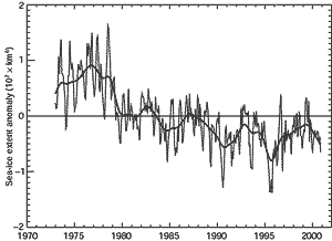
Figure 2.14: Monthly Arctic sea-ice extent anomalies, 1973 to 2000, relative
to 1973 to 1996. The data are a blend of updated Walsh (Walsh, 1978), Goddard
Space Flight Center satellite passive microwave (Scanning Multichannel Microwave
Radiometer (SMMR) and Special Sensor Microwave/Imager (SSM/I)) derived data
(Cavalieri et al., 1997) and National Centers for Environmental Prediction
satellite passive microwave derived data (Grumbine, 1996). Updated digitised
ice data for the Great Lakes are also included (Assel, 1983). |
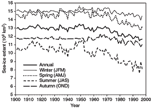
Figure 2.15: Time-series of annual and seasonal sea-ice extent in
the Northern Hemisphere, 1901 to 1998, (Annual values from Vinnikov et al.,
1999b; seasonal values updated from Chapman and Walsh, 1993.) |
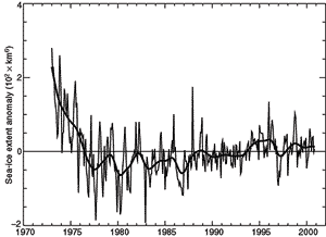
Figure 2.16: Monthly Antarctic sea-ice extent anomalies, 1973 to
2000, relative to 1973 to 1996. The data are a blend of National Ice Center
(NIC) chart-derived data (Knight, 1984), Goddard Space Flight Center satellite
passive-microwave (Scanning Multichannel Microwave Radiometer (SMMR) and
Special Sensor Microwave/Imager (SSM/I)) derived data (Cavalieri et al.,
1997) and National Centers for Environmental Prediction satellite passive-microwave
derived data (Grumbine, 1996). It is uncertain as to whether the decrease
in interannual variability of sea ice after about 1988 is real or an observing
bias. |
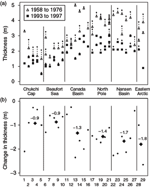
Figure 2.17: Mean ice thickness at places where early cruises were
(nearly) collocated with cruises in the 1990s. Early data (1958 to 1976)
are shown by open triangles, and those from the 1990s by solid squares,
both seasonally adjusted to September 15. The small dots show the original
data before the seasonal adjustment. The crossings are grouped into six
regions separated by the solid lines. From Rothrock et al. (1999). |
Sea-ice extent
Sea-ice extent is expected to become a sensitive indicator of a warming climate,
although only recently have long records become available in the Arctic, and
our knowledge of Antarctic sea-ice extent before the 1970s is very limited.
Sea-ice extent (the area within the ice-ocean margin)
was observed from space from 1973 to 1976 using the ESMR (Electrically Scanning
Microwave Radiometer) satellite-based instrument, and then continuously from
1978 using the SSMR (Scanning Multichannel Microwave Radiometer) (1978 to 1987)
and SSM/I (Special Sensor Microwave/Imager) (1987 to present). By inter-calibrating
data from different satellites, Bjørgo et al. (1997) and subsequently
Cavalieri et al. (1997) obtained uniform monthly estimates of sea-ice extent
for both hemispheres from November 1978 through to December 1996. Over this
period, the sea-ice extent over the Northern Hemisphere showed a decrease of
-2.8 ± 0.3%/decade (Parkinson et al., 1999), consistent with Johannessen
et al. (1995) (Figure 2.14). The Arctic decrease
was strongest in the Eastern Hemisphere and most apparent in summer (Maslanik
et al., 1996; Parkinson et al., 1999).
Hemispheric and regional data sets for the Arctic enable the satellite-derived
trends in Figure 2.14 to be placed into a century
scale context. Figure 2.15 shows annual time-series
of the Northern Hemisphere ice extent by season from 1901 to 1999 using in situ
data before the satellite era (Vinnikov et al., 1999a). It should be emphasised
that the spatial coverage of earlier data is not complete, with the largest
data voids in the autumn and winter. Because few data were available, the variability
of the autumn and wintertime series in Figure 2.15
is smaller during the early decades of the century. Essentially no data for
summer and autumn are available for the World War II period. The summer decrease
that is largely responsible for the overall downward trend during the satellite
era is present during the entire second half of the 20th century (Figure
2.15). This decrease represents about 15% of the average summer extent in
the first half of the 20th century. Spring values show a somewhat weaker negative
trend over the same period with a total reduction of near 8%, but there is only
a slight and uncertain downward trend in autumn and winter since about 1970.
The overall recent decrease of Arctic ice extent is, at first sight, consistent
with the recent pattern of high latitude temperature change, which includes
a warming over most of the sub-arctic land areas (Section
2.2.2.1). Some of this pattern of warming has been attributed to recent
trends in the atmospheric circulation of the North Atlantic Oscillation and
its Arctic-wide manifestation, the Arctic Oscillation (Section
2.6).
Related to the decline in sea-ice extent is a decrease in the length of the
sea-ice season (Parkinson, 2000) and an increase in the length of the Arctic
summer melting season between 1979 and 1998, also derived from satellite data.
The shortest season was 1979 (57 days) and the longest was in 1998 (81 days)
with an increasing trend of 5 days per decade (Smith, 1998, updated). The 7%
per decade reduction in the multi-year ice area during 1978 to 1998 is relatively
large compared with an approximately 2%/decade decrease in the total ice area
in winter (Johannessen et al., 1999). This reflects greater summer melting,
consistent with the results of Smith (1998).
Over the period 1979 to 1996, the Antarctic (Cavalieri et al., 1997; Parkinson
et al., 1999) shows a weak increase of 1.3 ± 0.2%/decade. Figure
2.16 (for 1973 to 1998) shows a new integrated data set of Antarctic sea-ice
extent that was put together for the new European Centre for Medium-range Weather
Forecasts (ECMWF) 40-year reanalysis that extends the record back to 1973. While
showing the same weak increase after 1979, it also suggests greater ice extents
in the mid-1970s. Although century scale time-series cannot be constructed for
the Antarctic, de la Mare (1997) has used whaling ship logs to infer significantly
greater ice extent in the Southern Ocean during the 1930s and 1940s than during
recent decades. The indirect nature of the earlier evidence, however, introduces
substantial uncertainty into this conclusion.
Antarctic Peninsula ice shelves
Although warming over Antarctica as a whole appears to have been perhaps half
of a degree in the last half century (Jacka and Budd, 1998), the Antarctic Peninsula
has warmed more rapidly, by more than 2°C since the 1940s (King, 1994). This
regional warming, whose cause has yet to be fully discovered (but see Section
2.6.6), has led to a southerly migration of the climatic limit of ice shelves
so that five ice shelves have retreated over the last century (Vaughan and Doake,
1996). The progressive retreat of ice shelves eventually resulted in the spectacular
final-stage collapse of the Prince Gustav and parts of the Larsen ice shelves
in 1995. Each left only a small residual shelf. After the collapse, James Ross
Island, situated off the northern end of the Antarctic Peninsula, is now circumnavigable
by ship for the first time since it was discovered in the early 19th century
(Vaughan and Lachlan-Cope, 1995).
Sea-ice thickness
Our knowledge of sea-ice thickness in the Arctic comes largely from upward sonar
profiling by USA and British submarines since 1958 and 1971, respectively. Rothrock
et al. (1999) compared late summer September to October data from 1993, 1996
and 1997 from an USA civilian submarine research programme with data from six
summer cruises from the period 1958 to 1976. Thickness was adjusted to mid-September
values to account for seasonal variability. The significant decline in mean
ice thickness was observed for all regions, increasing from the Canada Basin
towards Europe (Figure 2.17). Overall, there was
a mean reduction in thickness of 42% from 3.1 to 1.8 m the earlier period to
the present.
Wadhams and Davis (2000) have compared ice thickness changes between October
1976 and September 1996 between 81°N and 90°N near the 0° meridian.
The overall decline in mean sea-ice thickness between 1976 and 1996 was 43%.
Over every one degree of latitude, both a significant decline in ice thickness
and some completely open water were observed. Despite these dramatic results,
it is not known whether these changes reflect long-term change or a major mode
of multi-decadal variability. Vinje et al. (1998) measured the thickness of
ice exiting the Arctic Ocean through Fram Strait from 1990 to 1996 using moored
upward looking sonars and reported a rather different result. The mean annual
ice thickness in Fram Strait varied from 2.64 to 3.41 m. These observations
were consistent with Arctic Ocean-wide ice thickness estimates made by drilling
from Soviet Ice Stations from 1972 to 1981 and from submarine transects from
1960 to 1982, suggesting little change in ice thickness from the 1960s and 1970s
to the 1990s.
Nagurnyi et al. (1994, 1999) used measurements of long surface gravity waves
in the Arctic ice pack to estimate the mean ice thickness from wave attenuation.
These measurements are available for the winters of 1978/79 to 1990/91. Johannessen
et al. (1999) demonstrated a strong correlation between these ice thickness
estimates and the area of multi-year (MY) ice in the Arctic Ocean as obtained
from the SSMR and SSM/I. Both the area of MY ice and the ice thickness (winter)
estimates show a decrease of 5 to 7%/decade, considerably less than the submarine
estimates (late summer). Even though the satellite measurements have continued
for more than twenty years, they are inadequate to distinguish between changes
due to long-term trends or interannual/inter-decadal variability (Johannessen
et al., 1999).