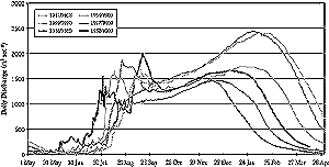
Figure 10-6: Decadal changes in hydrograph of the Niger River at Niamey Station between 1961 and 1999.
|
Box 10-3. Impact of Drought
in the Akasompo Dam (Graham, 1995) Multiple droughts in recent decades have forced Ghana to reduce the generation of hydroelectricity, provoking a national debate about power supply. The Akosombo and Kpong generating stations—commissioned in 1965 and 1982, respectively—provide the overwhelming bulk of Ghana's electricity. The two stations account for 1,072 MW of a total national power-generating capacity of 1,160 MW; Akosombo alone provides 833 MW. Until recently, most of the minority of Ghanaians who use electricity tended to regard the Volta hydroelectric dams as sources of uninterruptible power. The unprecedented drought of 1982-1983, which compelled rationing of electricity until 1986, shattered that illusion. And if that drought's power cuts jolted the nation's complacency about hydroelectricity, the 1994 incident concentrated minds forcefully on the impermanence of power from Akosombo and Kpong and the need for alternative sources. According to the Volta River Authority (VRA), the statutory power generating body, "cumulative inflow" into Volta Lake by the middle of August 1994 was "the worst…in the 50-year record of Volta river flows—worse than the same period in 1983." At its lowest, in early August, the level of Volta Lake was 73 m. This was well below the 75.6 m the VRA claims is the minimum level for generating power without risk of damaging the turbines. |
The heterogeneity of ground records in Africa imposes serious limitations in constructing future scenarios of water resources. Where consistent long-term climatic data are available, they indicate a trend toward reduced precipitation in current semi-arid to arid parts of Africa. Figure 10.3 of the Hulme et al. (2001) publication shows possible scenarios for different climatic regions of Africa. Although there is ambiguity in the Sahel, the simulations appear to indicate possible increases in precipitation in east Africa, whereas most simulations in southern Africa indicate reduced precipitation in the next 100 years.
Table 10-1 shows estimates of ranges of percentage changes in precipitation, potential evaporation, and runoff in African river basins as reconstructed from Arnell (1999, Figure 3). In some basins, estimates given by the HadCM3 simulation have been excluded where they appear to be outliers. A change in the hydrographs of large basins (Niger, Lake Chad, and Senegal) has been observed. Between the mean annual discharge of the humid and drought periods, the percentage of reduction varies from 40 to 60% (Olivry, 1993). Figure 10-6 shows the change in the hydrograph of the Niger River at the Niamey station. This illustrates a clear modification of the Niger River regime at Niamey. Similar situations are observed at the N'djamena station on the Chari at the entrance to Lake Chad. In the Nile basin, Sircoulon (1999) cites a reduction in runoff of 20% between 1972 and 1987, corresponding to a general decrease in precipitation in the tributary basins calculated by Conway and Hulme (1993). In recent years there have been significant interruptions in hydropower generation as a result of severe droughts (see Box 10-3).
Instrumental data and climate model simulations cited above indicate imminent water crisis in large parts of Africa. Several seminal works have appeared in the literature that analyze water for Africa, including Falkenmark (1989) and Gleick (1992, 1998).
Large basin-scale analyses often give the wrong impression that many areas of Africa are rich in water reserves, in which case local water problems could be solved easily by technology that would transfer water from the source to areas under stress, assuming that financial resources are available for such enterprises. Although in theory this may be a practical solution to many water problems in most of Africa, the very high costs associated with such projects make them impractical. Political goals such as self-sufficiency in food production and general socioeconomic development cannot be achieved under severe water scarcity (Falkenmark, 1989). Drought-prone zones of Africa already are water-limited, further increasing their vulnerability to water problems.
About 63% of the total land in Africa lies within transboundary river basins. Five major river basins—the Congo, Nile, Niger, Chad, and Zambezi—occupy about 42% of the geographical area and sustain more than 44% of the African population. Other shared basins in the continent are the Senegal, Gambia, Limpopo, Orange/Senqu, and Cunene Basins.
In west Africa, the dependency ratio—defined as the ratio between renewable water produced out of a country and the total renewable water of the same country—is more than 40% for seven of the nine countries comprising the Permanent Interstate Committee for Drought Control in the Sahel (CILSS). This ratio is nearly 90% for the Niger and the Mauritania. Similar transboundary dependencies are evident in southern Africa and on the Nile basin. The Congo basin is shared by the most countries (13), followed by the Niger and Nile basins (11 countries each) and the Zambezi and Chad basins (9 and 8 countries, respectively).
Figure 10-6: Decadal changes in hydrograph of the Niger River at Niamey Station between 1961 and 1999. |
The impact of changes in precipitation and enhanced evaporation could have profound effects in some lakes and reservoirs. Conway and Hulme (1993) and Calder et al. (1995) have discussed the hydrology and paleohydrology of various African Lakes. Magadza (1996) has examined the impact of drought on reservoirs in Zimbabwe. Reports fron Ghana (Graham, 1995) indicate severe drought impacts on this large reservoir. Studies show that, in the paleoclimate of Africa and in the present climate, lakes and reservoirs respond to climate variability via pronounced changes in storage, leading to complete drying up in many cases. Furthermore, these studies also show that under the present climate regime several large lakes and wetlands show a delicate balance between inflow and outflow, such that evaporative increases of 40%, for example, could result in much reduced outflow. In the case of Lake Malawi, it has been reported that the lake had no outflow for more than a decade in the earlier part of this century (Calder et al., 1995).
Predictions of response by the Nile to global warming are confounded by the fact that different simulations give conflicting results (Smith et al., 1995), varying from 77% flow reduction in the Geophysical Fluid Dynamics Laboratory (GFDL) simulation to a 30% increase in the Goddard Institute for Space Studies (GISS) model. Arnell's (1999) model results suggest increased precipitation in the Nile basin, but such gains are offset by evapotranspiration. Gleick (1992) projects that future climatic changes in the Nile basin would be significant and possibly severe. The response of the Nile basin to precipitation change is not linear, though it is symmetric for increased and decreased precipitation. Hulme (1992) shows a decline in total precipitation and overall warming of about 0.5°C over the last half on the 20th century. Conway and Hulme (1993) conclude that the effects of future climate change on Nile discharge would further increase uncertainties in Nile water planning and management, especially in Egypt. Nile precipitation responds more to changes in equatorial circulation, with little influence by the north African monsoon (Sestini, 1993).
Arnell (1999) shows that the greatest reduction in runoff by the year 2050 will be in the southern Africa region, also indicating that as the water use-to-resource ratio changes countries such as Zimbabwe and the Magreb region will shift into the high water-stress category. The Zambezi River has the worst scenario of decreased precipitation (about 15%), increased potential evaporative losses (about 15-25%), and diminished runoff (about 30-40%).
Lake Chad varies in extent between the rainy and dry seasons, from 50,000 to
20,000 km2. Precise boundaries have been established between Chad,
Nigeria, Cameroon, and Niger. Sectors of the boundaries that are located in
the rivers that drain into Lake Chad have never been determined, and several
complications are caused by flooding and the appearance or submergence of islands.
A similar process on the Kovango River between Botswana and Namibia led to a
military confrontation beteen the two states.
Vorosmarty and Moore (1991) have documented the potential impacts of impoundment,
land-use change, and climatic change on the Zambezi and found that they can
be substantial. Cambula (1999) has shown a decrease in surface and subsurface
runoff of five streams in Mozambique, including the Zambezi, under various climate
change scenarios. For the Zambezi basin, simulated runoff under climate change
is projected to decrease by about 40% or more.
Growing water scarcity, increasing population, degradation of shared freshwater ecosystems, and competing demands for shrinking natural resources distributed over such a huge area involving so many countries have the potential for creating bilateral and multilateral conflicts (Gleick, 1992). Feddema (1998, 1999) has evaluated the impacts of soil degradation and global warming on water resources for Africa. All major watersheds are affected by global warming; although the trend is toward drying in most locations, there are significant differences in watershed-level responses, depending on timing and distribution of rainfall, as well as soil water-holding capacity. Soil water-holding capacity is modified by the degree of soil degradation.
|
Other reports in this collection |
|