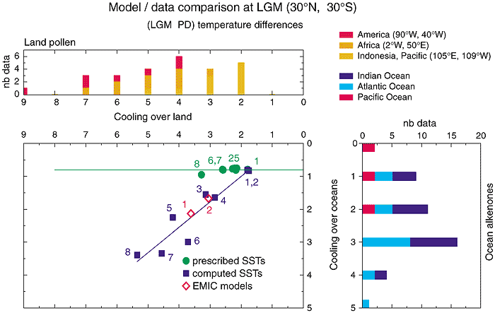
Figure 8.14: Annual mean
tropical cooling at the last glacial maximum: comparison between model results
and palaeo-data. (Centre panel) simulated surface air temperature changes over
land are displayed as a function of surface temperature changes over the oceans,
both averaged in the 30°S to 30°N latitudinal band, for all the PMIP simulations:
models with prescribed CLIMAP SSTs (circles) and coupled atmosphere-mixed layer
ocean models (squares) (from Pinot et al., 1999). Numbers refer to different models:
circles, 1: LMD4, 2-5: MRI2, ECHAM3, UGAMP, LMD5 (higher resolution), 6-7: CCSR/NIES1,
LMD5, 8: GEN2. Squares : 1: LMD4,2: UGAMP, 3: GEN2, 4: GFDL, 5: HADAM2, 6: MRI2,
7: CCM1, 8: CCC2 (names refer to Tables 8.1 and 8.5).
Results from two EMIC models including a dynamical ocean model have also been
displayed (diamonds): 1-UVIC (Weaver et al., 1998), 2-CLIMBER-2 (Petoukhov et
al., 2000).
The comparison with palaeo-data: (upper panel) over land is with estimates from
various pollen data for altitudes below 1,500m (the label nb data
refers to the number of data points in three different regions corresponding to
the temperature change estimate plotted in the abscissa) from (Farrera, et al.,
1999); (right panel) the distribution of SST changes estimated from alkenones
in the tropics from the Sea Surface Temperature Evolution Mapping Project based
on Alkenone Stratigraphy (TEMPUS) (Rosell-Melé, et al., 1998) (nb data:
same as upper panel, number of data points for each temperature change). Caution:
in this figure, model results are averaged over the whole tropical domain and
not over proxy-data locations, which may bias the comparison (e.g., Broccoli and
Marciniak, 1996). For example, for the pollen data, extreme values are obtained
for specific regions: weakest values over the Indonesia-Pacific region and coldest
values over South America.