10.5.1.2 Mean climate: Simulations using GCM boundary conditions
Since the SAR, evaluation of RCMs driven by GCM simulations of current climate
has gained much attention (Appendix 10.2), as this is
the context in which many RCMs are used (e.g., for climate change experiments).
Errors introduced by the GCM representation of large-scale circulations are
transmitted to the RCM as, for example, clearly shown by Noguer et al. (1998).
However, since the SAR, regional biases of seasonal surface air temperature
and precipitation have been reduced and are mostly within 2°C, and 50 to
60% of observations (with exceptions in all seasons), respectively (Giorgi and
Marinucci, 1996b; Noguer et al., 1998; Jones et al., 1999 for Europe; Giorgi
et al., 1998 for the continental USA; McGregor et al., 1998 for Southeast Asia;
Kato et al., 2001 for East Asia). The reduction of biases is due to both better
large-scale boundary condition fields and improved aspects of internal physics
and dynamics in the RCMs.
The regionally averaged biases in the nested RCMs are not necessarily smaller
than those in the driving GCMs. However, all the experiments mentioned above,
along with those of Leung et al. (1999a,b), Laprise et al. (1998), Christensen
et al. (1998) and Machenhauer et al. (1998) clearly show that the spatial patterns
produced by the nested RCMs are in better agreement with observations because
of the better representation of high-resolution topographical forcings and improved
land/sea contrasts. For example, in simulations over Europe and central USA,
Giorgi and Marinucci (1996a) and Giorgi et al. (1998) find correlation coefficients
between simulated and observed seasonally averaged precipitation in the range
of +0.53 to +0.87 in a nested RCM and 0.69 to +0.85 in the corresponding
driving GCM.
The role of the high-resolution forcing was clearly demonstrated in the study
of Noguer et al. (1998), which showed that the skill in simulating the mesoscale
component of the climate signal (Giorgi et al., 1994; Jones et al., 1995) was
little sensitive to the quality of the driving data (Noguer et al., 1998). On
the other hand, interactions between the large-scale driving data and high resolution
RCM forcings can have negative effects. In simulations over the European region
of Machenauer et al. (1998), the increased shelter due to the better-resolved
mountains in the RCMs caused an intensification of the GCM-simulated excessively
dry and warm summer conditions over south-eastern Europe.
Horizontal resolution is especially important for the simulation of the hydrologic
cycle. Christensen et al. (1998) showed that only at a very high resolution
do the mountain chains in Norway and Sweden become sufficiently well resolved
to yield a realistic simulation of the surface hydrology (Figure
10.10). An alternative strategy is to utilise a sub-grid scale scheme capable
of resolving complex topographical features (Leung et al., 1999a).
|
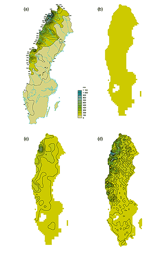
Figure 10.10: Summer (JJA) runoff for Sweden. (a) calculated with
a calibrated hydrological model, using daily meteorological station observations
and stream gauging stations (Raab and Vedin, 1995); (b) GCM simulation;
(c) 55 km RCM simulation; (d) 18 km resolution RCM. Units are mm (from
Christensen et al., 1998).
|