6.14 The Geographical Distribution of the Radiative Forcings
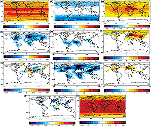
Figure 6.7: Examples of the geographical distribution of present-day
annual-average radiative forcing (1750 to 2000) due to (a) well-mixed greenhouse
gases including CO2 ,CH4 ,N2 O, CFC-11 and CFC-12 (Shine and Forster, 1999);
(b) stratospheric ozone depletion over the period 1979 to 1994 given by
WMO, 1995 (Shine and Forster, 1999); (c) increases in tropospheric O3 (Berntsen
et al., 1997; Shine and Forster, 1999); (d) the direct effect of sulphate
aerosol (Haywood et al., 1997a); (e) the direct effect of organic carbon
and black carbon from biomass burning (Penner et al., 1998b; Grant et al.,
1999); (f) the direct effect of organic carbon and black carbon from fossil
fuel burning (Penner et al., 1998b; Grant et al., 1999), (g) the direct
effect of anthropogenic emissions of mineral dust (Tegen et al., 1996);
(h) the first indirect effect of sulphate aerosol calculated
diagnostically in a similar way to Jones and Slingo (1997), but based on
a more recent version of the Hadley Centre model (HadAM3; Pope et al., 2000),
using sulphur emission scenarios for year 2000 from the SRES scenario (Johns
et al., 2001) and including a simple parametrization of sea salt aerosol
(Jones et al., 1999); (i) contrails (Minnis et al., 1999); (j) surface albedo
change due to changes in land use (Hansen et al., 1998), (k) solar variability
(Haigh, 1996). Note that the scale differs for the various panels. Different
modelling studies may show considerably different spatial patterns as described
in the text. (Units: Wm-2) |
While previous sections have concentrated upon estimates of
the global annual mean of the radiative forcing of particular mechanisms, this
section presents the geographical distribution of the present day radiative forcings.
Although the exact spatial distribution of the radiative forcing may differ between
studies, many of them show similar features that are highlighted in this section.
With the exception of well-mixed greenhouse gases, different studies calculate
different magnitudes of the radiative forcing. In these cases, the spatial distributions
are discussed, not the absolute values of the radiative forcing. It should be
stressed that the Figure 6.7 represents plausible examples
of geographical distributions only significant differences may occur in
other studies. In addition to Figure 6.7, Table
6.11 lists Northern to Southern Hemisphere ratio for forcings.
6.14.1 Gaseous Species
An example of the radiative forcing due to the combined effects of present
day concentrations of CO2, CH4, N2O, CFC-11 and CFC-12 is shown in Figure
6.7a (see Shine and Forster, 1999, for further details). The zonal nature
of the radiative forcing is apparent and is similar to the radiative forcing
due to well-mixed greenhouse gases from Kiehl and Briegleb (1993) presented
in IPCC (1994). The radiative forcing ranges from approximately +1 Wm-2 at the
polar regions to +3 Wm-2 in the sub-tropics. The pattern of the radiative forcing
is governed mainly by variations of surface temperature and water vapour and
the occurrence of high level cloud (Section 6.3).
An example of the radiative forcing due to stratospheric ozone depletion is
shown in Figure 6.7b which was calculated using zonal mean
stratospheric ozone depletions from 1979 to 1994 (WMO, 1995) by Shine and Forster
(1999). The zonal nature of the radiative forcing is apparent with strongest
radiative forcings occurring in polar regions which are areas of maximum ozone
depletion (Section 6.4). The gradient of the radiative
forcing tends to enhance the zonal gradient of the radiative forcing due to
gaseous species shown in Figure 6.7a.
An example of the radiative forcing due to modelled increases in tropospheric
O3 is shown in Figure 6.7c (Berntsen et al., 1997; Shine
and Forster, 1999). While the exact spatial distribution of the radiative forcing
may differ in other studies, the general pattern showing a maximum radiative
forcing over North Africa and the Middle East is common to many other studies
(Section 6.5). However, observational evidence presented
by Kiehl et al. (1999) suggests that this might be an artefact introduced by
the chemical transport models. The radiative forcing is much less homogeneous
than for well-mixed greenhouse gases, the maximum radiative forcing being due
to the coincidence of a relatively large O3 change, warm surface temperatures,
high surface reflectance, and cloud-free conditions.
6.14.2 Aerosol Species
An example of the direct radiative forcing due to sulphate aerosol is shown
in Figure 6.7d (Haywood et al., 1997a). In common with
many other studies (see Section 6.7), the direct radiative
forcing is negative everywhere, and there are three main areas where the radiative
forcing is strongest in the Northern Hemisphere corresponding to the main industrialised
regions of North America, Europe, and Southeast Asia. In the Southern Hemisphere,
two less strong regions are seen. The ratio of the radiative forcing in the
Northern Hemisphere to the Southern Hemisphere has been reported by many studies
and varies from 2 (Graf et al., 1997) to approximately 7 (Myhre et al., 1998c).
Generally, the strongest sulphate direct radiative forcing occurs over land
areas although the low surface reflectance means that areas of water close to
heavily industrialised regions such as the Mediterranean Sea, the Black Sea
and the Baltic Sea result in strong local radiative forcings. Due to the large
areal extent of ocean regions, the contribution to the total annual mean radiative
forcing from ocean regions is significant. The ratio of the annual mean radiative
forcing over land to that over oceans varies from approximately 1.3 (Kiehl et
al., 2000) to 3.4 (Boucher and Anderson, 1995) (see Table
6.4).
An example of the direct radiative forcing due to organic carbon and black
carbon from biomass burning is shown in Figure 6.7e (Penner
et al., 1998b; Grant et al., 1999). While the radiative forcing is generally
negative, positive forcing occurs in areas with a very high surface reflectance
such as desert regions in North Africa, and the snow fields of the Himalayas.
This is because biomass burning aerosols contain black carbon and are partially
absorbing. The dependency of the sign of the radiative forcing from partially
absorbing aerosols upon the surface reflectance has been investigated by a number
of recent studies (e.g., Chylek and Wong, 1995; Chylek et al., 1995; Haywood
and Shine, 1995; Hansen et al., 1997a). The strongest negative radiative forcing
is associated with regions of intense biomass burning activity namely, South
America, Africa, and Southern Asia and Indonesia and differ from the regions
where the sulphate radiative forcing is strongest (Figure 6.7d),
being confined to approximately 30oN to 30oS.
An example of the direct radiative forcing due to organic and black carbon
from fossil fuel burning is shown in Figure 6.7f (Penner
et al., 1998b; Grant et al., 1999). In contrast to the direct radiative forcing
from biomass burning (Figure 6.7e), the modelled direct
radiative forcing is generally positive except over some oceanic regions near
industrialised regions such as the Mediterranean Sea and Black Sea. This is
because, on average, aerosols emitted from fossil fuels contain a higher black/organic
carbon ratio than biomass aerosols (Penner et al., 1998b; Grant et al., 1999)
and are thus more absorbing. Comparison of the radiative forcing due to sulphate
aerosols reveals that the areas of strongest sulphate direct radiative forcing
are offset to some degree by the radiative forcing due to fossil fuel emissions
of black carbon as shown in calculations by Haywood et al. (1997a) and Myhre
et al. (1998c). Additional regions of moderate positive radiative forcing are
present over areas of high surface reflectance such as northern polar regions
and the North African deserts.
An example of the direct radiative forcing due to anthropogenic emissions of
mineral dust is shown in Figure 6.7g (Tegen et al., 1996).
Areas of strong positive forcing are shown over regions with high surface reflectance
such as desert regions in Africa and over the snow surfaces of the Himalayas
and areas of strong negative forcing are apparent over ocean areas close to
mineral dust sources such as off the coasts of Arabia and North Africa. The
exact switchover between areas of positive and negative radiative forcing are
not well established owing to uncertainties in the modelled mineral aerosol
optical properties and depends upon the assumed single scattering albedo (Miller
and Tegen, 1998), the long-wave properties and altitude of the aerosol (Section
6.7.6).
An example of the first indirect radiative effect (i.e., changes
in the cloud reflectivity only) due to anthropogenic industrial aerosols is
shown in Figure 6.7h. The forcing is calculated diagnostically
in a similar way to Jones and Slingo (1997), but is based on a more recent version
of the Hadley Centre model (HadAM3; Pope et al., 2000), uses updated sulphur
emission scenarios from the SRES scenario for the year 2000 (Johns et al., 2001)
and also includes a simple parametrization of sea salt aerosol (Jones et al.,
1999). The spatial distribution of the indirect radiative forcing is quite different
from the direct radiative forcing with strong areas of forcing off the coasts
of industrialised regions (note the change in scale of Figure
6.7h). There is a significant radiative forcing over land regions such as
Europe and the Eastern coast of North America, and Southeast Asia. The spatial
distribution of the indirect radiative forcing will depend critically upon the
assumed spatial distribution of the background aerosol field and the applied
anthropogenic perturbation and differs substantially between studies (see Section
6.8.5). It would have a very different spatial distribution if the effect
of biomass burning aerosols were included. The second indirect effect
whereby inclusion of aerosols influences the lifetime of clouds is not considered
here due to the complications of necessarily including some cloud feedback processes
in the estimates (Section 6.8.5), but may well resemble
the spatial distribution of the first indirect effect.
6.14.3 Other Radiative Forcing Mechanisms
The spatial distribution of three other radiative forcing mechanisms are considered
in this section: the radiative forcing due to contrails, land-use change, and
solar variability. The radiative forcing due to other constituents such as nitrate
aerosol and aviation-induced cirrus that are very difficult to quantify at present
are not presented as geographic distributions of the radiative forcing are currently
considered to be speculative.
An example of the present day radiative forcing due to the effect of contrails
is shown in Figure 6.7i (Minnis et al., 1999). The radiative
forcing is very inhomogeneous, being confined to air-traffic corridors (IPCC,
1999). Future scenarios for aircraft emissions may shift the current geographical
pattern of the radiative forcing as discussed in IPCC (1999).
An example of an estimate of the radiative forcing due to changes in land use
is shown in Figure 6.7j (Hansen et al., 1998). The areas
of strongest negative forcing occur at northern latitudes of the Northern Hemisphere
due to the felling of forests which have a lower albedo when snow is present
(see Section 6.13). Additional effects are due to the
change in albedo between crop lands and naturally occurring vegetation. Examples
where the radiative forcing is positive include areas where irrigation has enabled
crop-growing on previously barren land.
An example of the present day radiative forcing due to solar variability is
shown in Figure 6.7k. The solar radiative forcing was calculated
by scaling the top of the atmosphere net solar radiation such that the global
average is +0.3 Wm-2 (as deduced for global average radiative forcing
since 1750, see Section 6.13.1). Thus it assumes
a 0.125% increase in solar constant and no change in any other parameter (e.g.,
O3, cloud). The cloud and radiation fields were calculated within
a run of the UGAMP GCM (Haigh, 1996). The strongest radiative forcings exist
where the surface reflectance is low (i.e., oceanic regions) and the insolation
is highest (i.e., equatorial regions). The solar radiative forcing is also modulated
by cloud amount, areas with low cloud amount showing the strongest radiative
forcing. The solar radiative forcing is more inhomogeneous than the radiative
forcing due to gaseous species (Section 6.14.1), but more
homogeneous than the radiative forcing due to aerosol species (Section
6.14.2).
While the preceding sections have shown that the radiative forcing due to the
different forcing mechanisms have very different spatial distributions, it is
essential to note that the forcing/response relationship given in Section
6.2 relates global mean radiative forcings to global mean temperature response.
Thus, it is not possible to simply map the geographical radiative forcing mechanisms
by assuming a globally invariant climate sensitivity parameter to predict a
geographic temperature response, due to the complex nature of the atmosphere-ocean
system. Rather, the effects of spatial inhomogeneity in the distribution of
the radiative forcing may lead to locally different responses in surface temperature
(Section 6.2) indicating that the spatial distributions
of the radiative forcing need to be accurately represented to improve regional
estimates of surface temperature response and other physical parameters.