2.2.5 Changes in the Cryosphere
This chapter does not describe changes in the major ice sheets as this is dealt
with in detail in Chapter 11.
2.2.5.1 Snow cover, including snowfall
Satellite records indicate that the Northern Hemisphere annual snow-cover extent
(SCE) has decreased by about 10% since 1966 largely due to decreases in spring
and summer since the mid-1980s over both the Eurasian and American continents
(Figure 2.13a; Robinson, 1997, 1999). Winter and
autumn SCE show no statistically significant change. Reduction in snow cover
during the mid- to late 1980s was strongly related to temperature increases
in snow covered areas (Figure 2.13b). There is
a highly significant interannual (+0.6) and multi-decadal correlation between
increases in the Northern Hemisphere spring land temperature and a reduction
in the Northern Hemisphere spring snow cover since data have been available
(1966). Snow cover extent has decreased about 10% since 1966. The improvements
in the quantity and quality of the visible satellite imagery used to produce
the operational snow-cover product cannot account for the observed changes in
snow cover.
Longer regional time-series based on station records and reconstructions suggest
that Northern Hemisphere spring and summer SCEs in the past decade have been
at their lowest values in the past 100 years. In the other seasons, it is likely
that extents in the latter portion of the 20th century exceeded those of earlier
years (Brown, 2000).
Reconstructions for North America suggest that while there has been a general
decrease in spring SCE since 1915, it is likely that winter SCE has increased
(Brown and Goodison, 1996; Frei et al., 1999; Hughes and Robinson, 1996; Hughes
et al., 1996). Similar to the results in North America, in Eurasia April SCE
has significantly decreased; but lack of data has prevented an analysis of winter
trends (Brown, 2000). Over Canada, there has been a general decrease in snow
depth since 1946, especially during spring, in agreement with decreases in SCE
(Brown and Braaten, 1998). Winter depths have declined over European Russia
since 1900 (Meshcherskaya et al., 1995), but have increased elsewhere over Russia
in the past few decades (Fallot et al., 1997). The common thread between studies
that have examined seasonality is an overall reduction in spring snow cover
in the latter half of the 20th century.
There have been relatively few studies of snowfall trends across the globe.
Statistically significant increases in seasonal snowfall have been observed
over the central USA in the 20th century (Hughes and Robinson, 1996). In recent
decades, snowfall has also been heavier to the lee of the North American Great
Lakes than earlier in the century (Leathers and Ellis, 1996). These findings
are in line with observations from Canada and the former Soviet Union, reflecting
a trend towards increased precipitation over the mid-latitude lands in the Northern
Hemisphere (Groisman and Easterling, 1994; Brown and Goodison, 1996; Ye et al.,
1998).
|
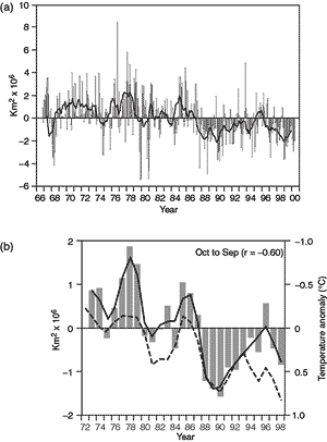
Figure 2.13: (a) Anomalies of monthly snow cover over the Northern
Hemisphere lands (including Greenland) between November 1966 and May 2000.
Also shown are twelve-month running anomalies of hemispheric snow extent,
plotted on the seventh month of a given interval. Anomalies are calculated
from NOAA/NESDIS snow maps. Mean hemispheric snow extent is 25.2 million
km2 for the full period of record. the curve of running means
is extrapolated by using period of record monthly means for 12 months
in the late 1960s in order to create a continuous curve of running means.
Missing months fell between May and October, and no winter months are
missing. June 1999 to May 2000 values are based on preliminary analyses.
(b) Seasonal snowcover anomalies (in million km2) versus temperature
anomalies (in °C). Both snow and temperature anomalies are area averages
over the region for which climatological values of seasonal snow-cover
frequency (based on the 1973 to 1998 period) are between 10 and 90%. Season
is indicated at the top of each panel. Axis for snow anomaly on the left-hand-side
y axis, axis for temperature anomaly is on the right-hand-side y axis.
Bar plot indicates time-series of snow cover anomalies. Continuous colour
curve indicates nine-point weighted average of snow-cover anomaly. Dashed
black curve indicates time-series of nine-point weighted average of area
average temperature anomaly. Snow-cover calculations are based on the
NOAA/NESDIS snow cover data for the period 1973 to 1998 (updated from
Robinson et al., 1993). Temperature calculations are based on the Jones
data set, hence anomalies are with respect to the time period 1961 to
1990. Snow anomalies are with respect to the time period 1973 to 1998.
Correlation coefficient (r) between seasonal snow cover anomalies and
temperature anomalies is indicated in parentheses. (Figure contributed
by David A. Robinson and Anjuli Bamzai, Rutgers University.)
|